Back پرينسيس رويال (جزيره) ARZ Принсес Ройъл Bulgarian Illa Princess Royal Catalan Princess Royal Island (pulo sa British Columbia) CEB Princess Royal Island Danish Princess Royal Island German Isla Princesa Real Spanish جزیره رویال پرینسس Persian Île Princess Royal French Illa Princess Royal Galician
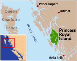
 Princess Royal Island is located on the Inside Passage to the east of Hecate Strait | |
 | |
| Geography | |
|---|---|
| Location | North Coast Archipelago (Central Coast) |
| Coordinates | 52°55′N 128°50′W / 52.917°N 128.833°W |
| Area | 2,251 km2 (869 sq mi) |
| Administration | |
Canada | |
| Province | British Columbia |
| Region | North Coast |
| Demographics | |
| Ethnic groups | Tsimshian territory |
Princess Royal Island is the largest island on the North Coast of British Columbia, Canada. It is located amongst the isolated inlets and islands east of Hecate Strait on the British Columbia Coast. At 2,251 square kilometres (869 sq mi), it is the fourth largest island in British Columbia.[1] It was named in 1788 by Captain Charles Duncan, after his ship Princess Royal.[2]
- ^ Pacific Coast Islands Archived 2013-01-22 at the Wayback Machine, The Atlas of Canada
- ^ "Princess Royal Island". BC Geographical Names.